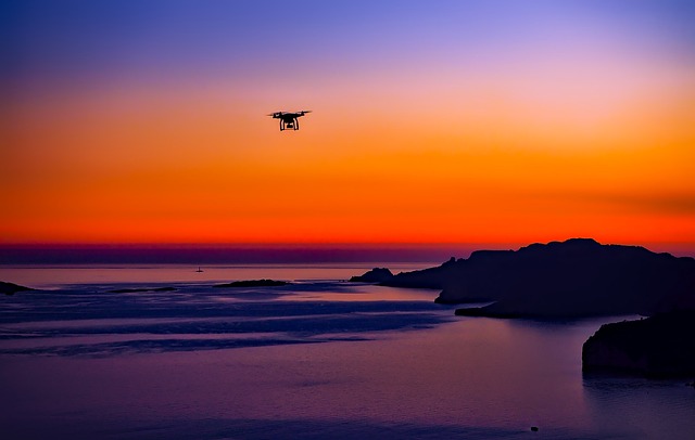
Learn drone technology and aerial imaging with a clear, safety-first pathway
Celtic Journal is an Irish learning platform for drone fundamentals, responsible operation, aerial photography, and mapping concepts. Lessons are written for beginners and structured like a practical field notebook: what to check, what to capture, and how to interpret what you see.
We teach responsible operation and educational field methods. This site does not offer surveillance services or military applications.
Lessons are designed to support responsible learning. Always follow local rules, site permissions, and manufacturer documentation for your aircraft.
What we do
Celtic Journal publishes structured learning material that helps newcomers understand drones as a practical tool: how they stay stable, how sensors interpret the world, and how to plan a flight that is safe, legal, and respectful of the places you visit. Instead of treating drones as a shortcut, we treat them as a system: aircraft + battery management + radio link + camera + positioning + operator judgement. The unglamorous details are where most mistakes happen, so we write about them plainly.
The platform covers core flight concepts (orientation, wind handling, return-to-home planning), imaging basics (shutter speed vs. motion blur, exposure consistency, and simple colour management), and mapping fundamentals (overlap, ground sampling distance, and why consistent altitude matters). We also include environmental observation modules that focus on documenting landscapes and habitats with care, using repeatable capture patterns and good note-taking rather than guesswork.
This is an education site. We do not offer surveillance services, and we avoid topics that encourage unsafe or intrusive operation. Our goal is straightforward: help learners build competence, keep flights predictable, and produce imagery and data that can be used for study projects and outdoor exploration.
A bento-style curriculum you can scan in minutes
Each track is written to be used outdoors. Expect short lessons, realistic constraints, and checklists that fit on a phone screen. When a topic needs depth—like photogrammetry overlap or GNSS drift—we slow down and show examples.
Drone Fundamentals
A grounded introduction to lift, stability, GPS-assisted modes, and the practical reasons drones drift or wobble. You will learn pre-flight checks, safe take-off and landing habits, and what “failsafe” settings actually do.
The module uses simple mental models—orientation, wind, and battery headroom—so you can make calm decisions when a flight does not go to plan.
Safe Flight Guides
Step-by-step operational habits: weather read, site permission, home point verification, and battery temperature considerations. Written like a practical “go / no-go” checklist.
Aerial Photo and Video
Learn stable movement patterns, shutter planning, and simple composition for coastal walks, hills, and urban architecture. Includes ND filter guidance and motion blur basics.
Mapping and Surveying Concepts
A practical introduction to photogrammetry planning: overlap, sidelap, consistent altitude, and why rolling shutter matters. We explain ground sampling distance (GSD) in plain terms and show how it affects what you can measure.
Sensors and Data Literacy
Understand camera sensors, GNSS, barometers, and obstacle sensing limits. You will learn how to log conditions and avoid misreading “precision” as “accuracy.”
How learning works
The platform is structured as a progression. Each step is designed to reduce cognitive load in the field: fewer surprises, cleaner routines, and a clear boundary between practice flights and more technical capture tasks like mapping grids. Expect practical terminology used by drone operators—home point, geofencing, GNSS multipath, and overlap—explained without assuming prior experience.
-
01
Start with fundamentals and safe defaults
Learn how stabilisation modes work, what the aircraft is doing during hover, and how return-to-home is configured. We also cover battery headroom and why “last bar” landings create avoidable risk.
- Pre-flight checks you can repeat every time
- Basic emergency actions without panic
- Understanding wind and drift near cliffs and trees
-
02
Build camera control and stable movement
Aerial imaging is mostly planning. You will practise consistent speed, gentle yaw, and exposure choices that keep footage clean. We focus on techniques that work even with entry-level drones.
- Shutter speed and motion blur basics
- Simple composition for landscape and city scenes
- Managing glare and changing light near water
-
03
Introduce mapping and surveying concepts
Mapping is a disciplined capture pattern, not a magic setting. We explain overlap, flight lines, and how GNSS multipath can influence repeatability near buildings and steep terrain.
- Overlap and sidelap explained with real examples
- Ground sampling distance (GSD) in plain language
- Field notes that make processing easier later
-
04
Apply skills to environmental observation projects
Environmental learning works best when it is careful and repeatable. We outline non-intrusive observation methods for landscapes and habitats, with a strong focus on permissions and avoiding disturbance.
- Site selection and flight planning with minimal impact
- Documenting change over time using consistent angles
- Ethical boundaries: avoid flying near people and wildlife
Learning outcomes and examples
Instead of marketing claims, we share what learners typically produce by following the checklists and practice flights. Each example is a small, specific win: smoother footage, fewer unexpected warnings, and clearer capture planning. In technical terms, it is about reducing variance—consistent settings, consistent patterns, and consistent decision-making.
Mini case study: coastal walk video plan
Problem: footage looked jittery due to fast yaw and inconsistent shutter choices in bright conditions. Approach: a simple “three moves” pattern (rise, slow forward, gentle yaw), plus a target shutter range and a short pre-take checklist. Outcome: smoother clips and fewer discarded takes, with a repeatable plan that worked on windy days.
Attribution: Niamh D., outdoor photography student, Dublin
Mini case study: first mapping grid
Problem: early grids produced uneven coverage because altitude wandered and overlap was inconsistent. Approach: a planning worksheet that set a fixed altitude, a slower ground speed, and a capture interval matched to the camera. Outcome: cleaner coverage and a better understanding of how overlap, GSD, and wind interact in real sites.
Attribution: Seán K., engineering society member, Galway
Client feedback
“The safety checks were the difference for me. I stopped guessing about return-to-home altitude and learned to confirm the home point every time. The guide also explained why GPS can feel ‘odd’ near buildings, which made my practice flights calmer and more predictable.”
Aidan K., hobby pilot, Cork
“The mapping section didn’t pretend it was easy. It showed the capture pattern, the overlap numbers, and the note-taking that actually helps. I used the worksheet on a small site and finally understood what sidelap does to coverage.”
Mairead R., geography student, Limerick
“I wanted better aerial photos without turning it into a big production. The camera lessons were straightforward: slow movement, consistent shutter choices, and a short checklist. My clips look cleaner and I waste less time fixing issues later.”
Tom D., outdoor enthusiast, Wicklow
Contact and workshop interest
Use this form to ask about course access, small-group workshops, or how to choose a learning path for aerial photography or mapping basics. Messages are reviewed by the Celtic Journal team in Dublin. We typically reply within 1 business day. We do not sell personal data, and we only use your details to respond to your request.
What happens next
- We review your message and reply with the most relevant next step: a course link, a reading list, or workshop options.
- If your question involves mapping, we may ask for basic context such as site type and the kind of output you want (photos, video, or a simple map).
- We will never ask for government IDs or financial account details through this form.
FAQ
Questions we hear often from beginners and hobby pilots. If you cannot find what you need, send a message and include the drone model and your typical flying locations (coast, parks, hills, or urban areas).
Do I need to start with a specific drone model?
No. Fundamentals transfer well across consumer drones. A stable GPS-assisted drone with a reliable return-to-home feature is a sensible starting point. The lessons focus on concepts like home point confirmation, wind planning, and safe landing routines rather than brand-specific features.
What does “responsible operation” mean in practice?
It means treating every flight as a small risk assessment. You confirm the location is appropriate, avoid flying near people, respect property and wildlife, and keep the flight predictable. We also encourage methodical record-keeping: weather notes, battery cycles, and any warnings you see on-screen.
Is mapping the same as taking aerial photos?
Mapping is a specific capture method designed for measurement and reconstruction. It typically requires consistent altitude, controlled speed, and planned overlap. A nice photo can be captured anywhere; a mapping grid is a repeatable pattern that prioritises coverage and consistency.
Do you cover environmental monitoring?
We cover environmental observation for education, such as documenting landscapes, coastlines, or habitats with minimal disturbance. The emphasis is on respectful site behaviour, permissions, and careful flight planning. We do not publish content that encourages intrusive monitoring of people.
What data do you collect when I send a message?
We collect the contact details you provide (such as name and email) and the message content so we can respond. We may also collect basic technical data like IP address for security and abuse prevention. Details are explained in our Privacy Policy, including how to request deletion.
Can I learn from resources only, without a workshop?
Yes. Many learners start with the Drone Fundamentals course and the Safe Flight guide, then use the Learning Resources section to deepen specific topics like sensor limits, exposure planning, and mapping terminology.
Get a calm, beginner-friendly learning plan
Tell us what you want to learn—safe flying, aerial photography, or mapping basics—and we will suggest a starting path and resources that fit your goals.